Digital Soil Map

Enabling next-level precision irrigation

There is a big difference between soil maps that are created in analog and subjective environments and then digitized and soil maps that are created, from start to finish, using objective, digital methods. LandScan uses the worlds most advanced sensing systems and the unique analytics that enable us to produce spatially and statistically accurate 3D digital soil maps. This accuracy is critical to the effective deployment of precision applications and technologies as well as advanced crop analytics.

Humans are better at understanding information if it can be displayed in a way that is intuitive. It is not practical to display the thousands of unique and independent sensor data dimensions in 3D for human consumption. At the same time, it is not necessary to display data at all for the analytics to assess, interpret, and classify the complex relationships between site characteristics. However, we do create some of these maps to help our customers understand the information better.

LandScan Digital Soil Maps are Different

LandScan Digital Soil Maps are unique and are the only true full-profile, digital 3D products in the world. The primary benefit of LandScan soil information products compared to any other is that they connect the information obtained with the DSC and complimentary sensors across space and through the root zone. The variety and complementarity of the DSC sensor suite produces a 3D information matrix that is second to none in its analytical utility.

Because it takes about a minute to collect each DSC observation profile, it is possible to overcome the critical mass of data necessary to make a spatially and statistically accurate soil map. The spatial resolution of the intended maps can be tuned to the application where crops with more intense and costly management conditions merit the creation of a more robust digital twin. Applications at the research scale or when utilizing the DSC for exploration and discovery have varying resolution requirements as well.

Information Products

The thousands of sensor data points can be fused, sliced, and diced a million different ways. LandScan combines a strong team of experts in agronomy and analytics to derive meaningful and actionable output. The resulting soil information products are integrated later in the Root Cause Analytics (RCA) tool in order to derive actionable insights.

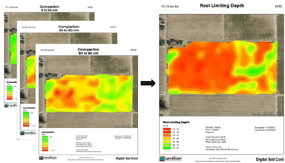
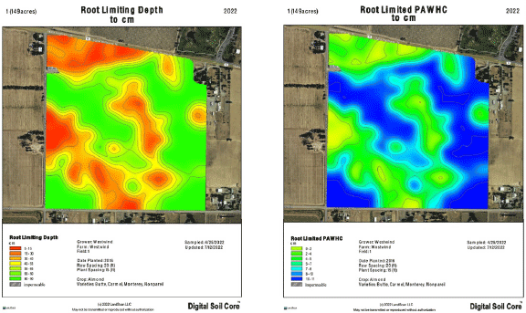
One of the advantages of continuous vertical profile data is that it is possible to identify thin layers of soil that impact water and nutrient transport and storage as well as root development and other chemical and biological processes. One example is the root zone plant available water (RZPAW) information product that combines data obtained from all the sensors to understand the:

  • amount of water the soil can hold
  • in conjunction with how much water the root can extract from the soil
  • in the zone the roots occupy based on root penetrability

No other technology suite in the world can produce this type of information.

Slicing Up the Field

There are countless ways to extract useful information for the field-scale digital twin once it is created. Different depth increments can be selected using an almost infinite number of combinations from the multiple information dimensions. Of course, there are data mining methods that enable LandScan to explore and extract the most significant data. These layers can be combined in many ways to create practical, scalable and thus actionable insights.

Make Contact

Let's start a conversation

Book Services

Book Service for fall 2024 and 2025

We are currently booking services for fall 2024 and 2025.  

  • No payment required until 60 days prior to scheduled work.
  • Cancel anytime until down payment is made.
  • Once your reservation is placed, our team of experts will contact you to develop a work plan and cost estimate and then schedule your services.