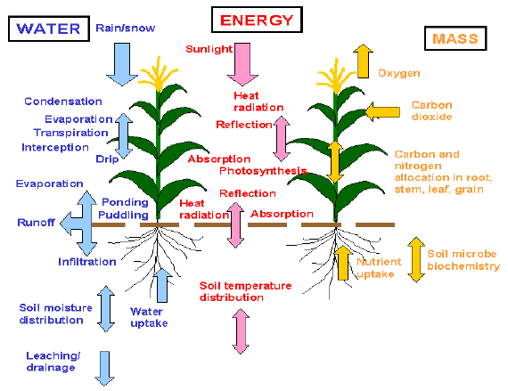
Knowing where your water is beneath the soil is one thing. Knowing how it’s moving through the soil column, draining below your roots, or being taken up by them provides a wholly different level of actionable insight. Like the steady dribble of tap water through a soggy sponge, the amount of water in the sponge doesn’t tell you how much water is flowing through it. Your soil is the same way. Fortunately, the way your soil – like the sponge – responds to the transient nature of irrigation events provides strong clues to how water moves through that very specific soil profile. LandScan’s AI-driven FluxH2O model deciphers these clues over time to accurately quantify deep drainage, and soon root uptake too.
The FluxH2O system addresses an important and growing “pain point” for agricultural producers, providing quantitative information on how much water moves beyond the root zone and into “deep drainage,” either as intentional recharge (in water cycle regulated region) or as over-application of a costly resource that can also waste applied nutrients and create a regulatory liability.
Until now, no practical means has existed to make soil water flux measurements in the actual growing environment. Heat pulse techniques and lysimeter-based methods such as capillary wicks have not led to commercially available products because they suffer serious practical drawbacks and weighing lysimeters are simply not practical in a production context.
The FluxH2O model is built on LandScan’s high-spatial-resolution FluxH2O monitoring technology, without which the AI that drives Flux H2O system would not be feasible.