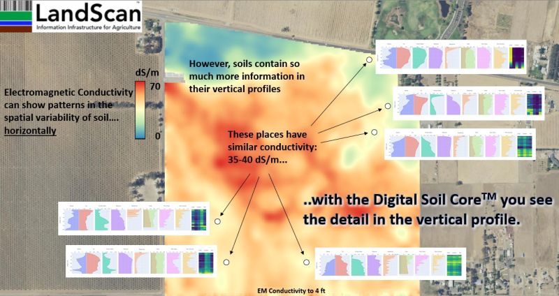
Beware of shifting sands! There are many who utilize EM/EC sensors to produce ‘soil maps’. These sensors do not produce soil maps and are almost always ‘oversold’ as such.
The providers utilize the patterns generated from these sensors to interpolate and extrapolate their soil observations along with topography and/or yield making the false assumption that the same sensor output means the same thing within the same field. It usually does not.
The EM/EC patterns change throughout the year too. Think about watching a puddle evaporate from a parking lot. The parking lot, for all practical purposes, is flat. The puddle however, depending on when you look at it, changes shapes and forms lobes and islands as it ebbs (or flows). The same thing happens in the soil, but in far more complicated 3D patterns. The pattern, and how it appears to an EM/EC sensor, will absolutely change as the soil moisture changes.
In addition to moisture, the EM/EC signal is influenced by many other properties such as: texture, density, salinity, mineralogy, CEC, organic matter, pH, structure, and many others in combination as well as their distribution in the soil profile. These tools average (subtract) layers at set depths, but of course the soil layer depths and thicknesses themselves are changing within the field. All of this simply cannot be delineated with one type of sensor signal.
LandScan does utilize these tools as one input in our site characterization protocol, but as you can see from the map shown here (and for every field) this data must be considered, calibrated, and interpreted (ground-truthed) in the context of the multiple-sensor data obtained from the Digital Soil Core (DSC). Only then can you produce a true 3D Digital Soil Map!
#ii4ag #digitalsoilcore #digitalagriculture #digitaltwins #digitalsoilmap
