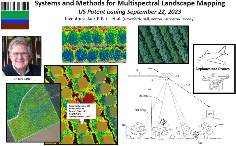
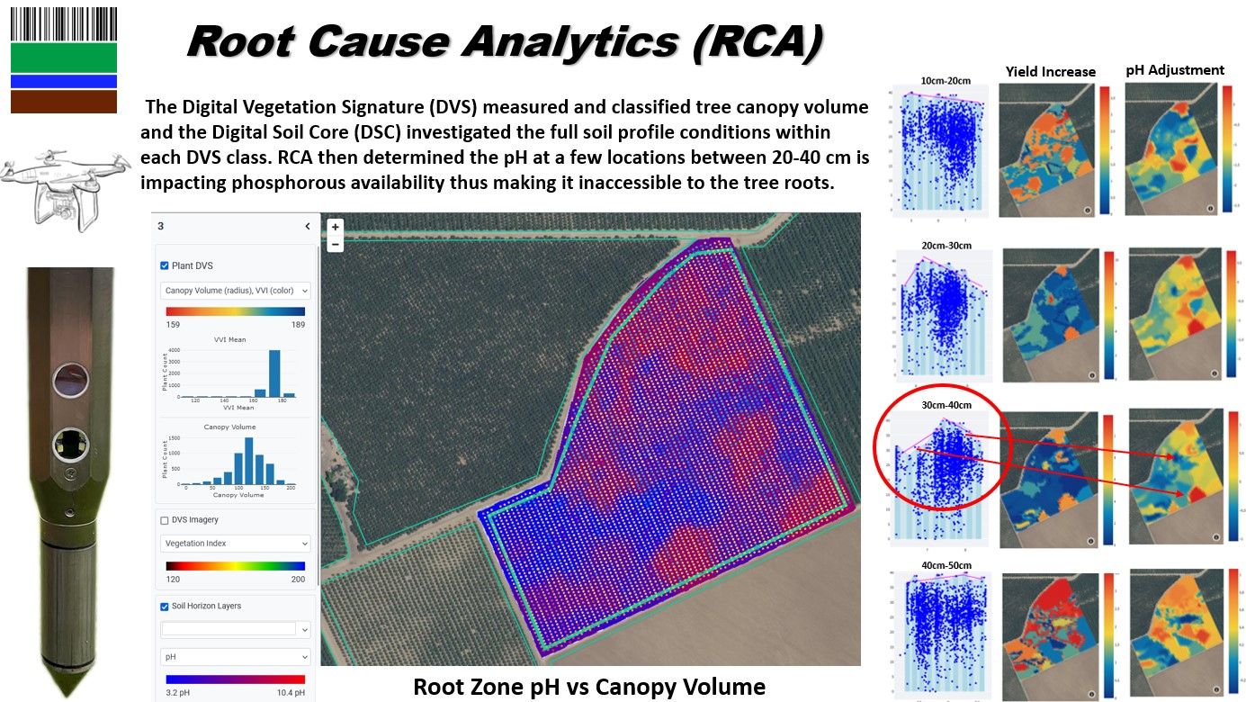
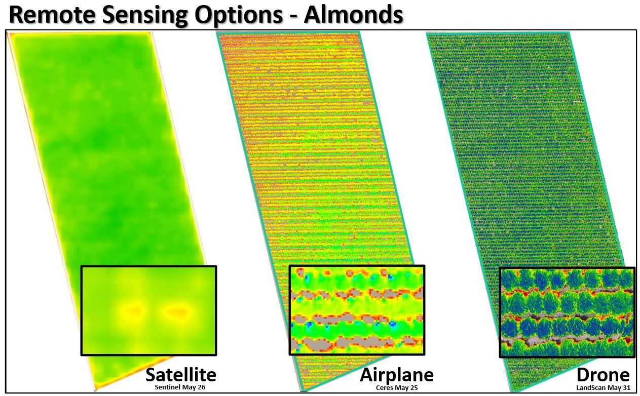
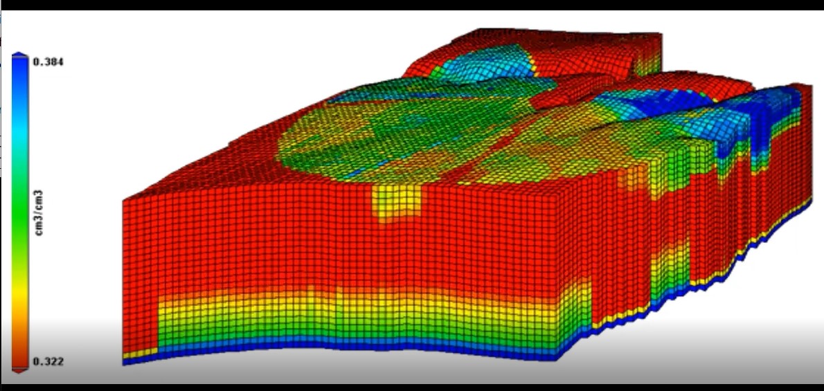
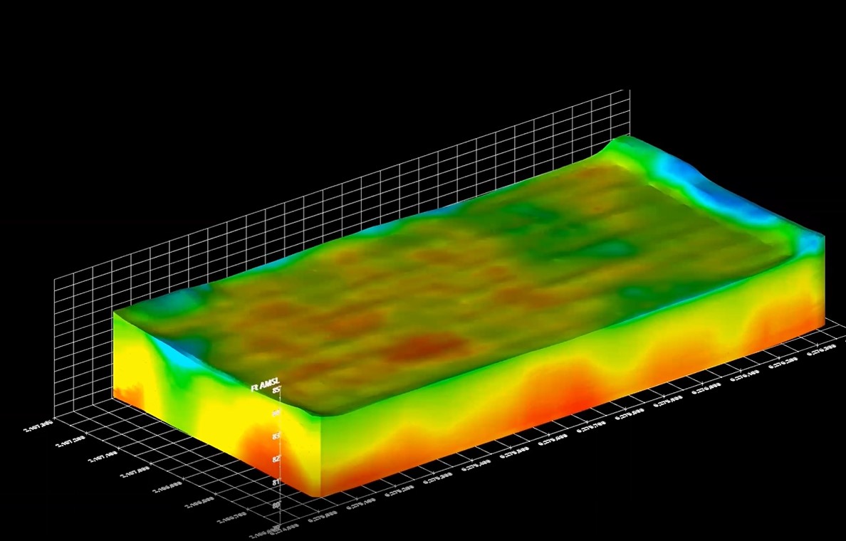
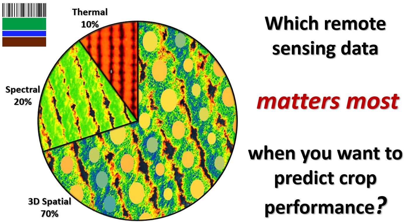
True 3D Soil Information
There is so much to learn and discover about soil! #ii4ag #digitalsoilcore #digitalagriculture #digitaltwins #computationalagronomy

There is so much to learn and discover about soil! #ii4ag #digitalsoilcore #digitalagriculture #digitaltwins #computationalagronomy

The business of looking down is looking up! LandScan’s is adding another patent to our growing technology platform. Our comprehensive system combines both the hardware and software necessary to produce the type of high resolution spectral and thermal photogrammetry required for advanced computational agronomy. The technology is for airborne applications (drones and airplanes) because it

This is an example of how LandScan’s technology works together to make discoveries and solve complex agronomic challenges. No other technology suite in the world can obtain this information and produce these analytics. Learn more: https://landscan.ai/ #ii4ag #rootcauseanalytics #digitalvegetationsignature #digitalsoilcore #digitalagriculture #digitaltwins

Three remote sensing options that all have their place in the agricultural industry. #digitalagriculture #remotesensing #digitalvegetationsignature

The Digital Soil Core (DSC) is the only technology in the world capable of generating an in-situ full profile scan of specific nutrients in the soil. Data collected in one day from an almond orchard in California in spring 2023. Data analyzed by researchers at the University of Nebraska and the University of Florida. Peer

There are many, many types of organic matter of all sizes and each holds clues to understanding the soil environment. All of this data was obtained from an almond orchard (loamy sand) in one day in spring 2023 in California. Statistical analysis performed by researchers at Univ. of Nebraska and Univ. of Florida (peer reviewed

A new season is upon us and LandScan is back in the field! Stay tuned for lots of paradigm busting and exciting discoveries in 2023. #digitalsoilcore #rootcauseanalytics #digitalagriculture #digitaltwins #agtech

LandScan is expanding the horizons of soil science! More fascinating discoveries in the new field of subsurface remote sensing using the #digitalsoilcore. What is this? Fungus? Using these tools is becoming more and more interesting every day. We are seeing things never-before-observed and we are excited about what’s to come. #ii4ag #digitaltwins #digitalagriculture #subsurfaceremotesensing #soilhealth

There are many practical reasons why producing #digitaltwins for #digitalagriculture is important. Empower your voxels! Here true 3D soil information relating to how much water the soil can hold that is available to the plant is used for a precision center pivot irrigation application. Learn more: https://landscan.ai/platform/dynamic-modeling/ #ii4ag

Ever seen anything like this? These types of high resolution digital 3D soil maps can be produced for almost any soil property or attribute using the #digitalsoilcore. While it is not necessary to produce these visuals for site characterization and analysis purposes, it is useful for ‘we humans’ to see this so we understand the

The business of looking down is looking up! LandScan is pioneering the new field of subsurface remote sensing where an image is worth a thousand data points. Just like images obtained from satellites or airborne platforms can be processed, analyzed, and classified so too can images of the full soil profile obtained with the DSC

Characterizing the soil microbiome will never be the same! These features are the diameter of a human hair. We observed several this week in-situ at multiple depths (30-120cm) in a vineyard. The Digital Soil Core (DSC) is capable of characterizing features and properties that are not possible or practical through soil sampling.

“Everything is everywhere, but the environment selects” is the critical maxim for all things soil health and microbiology. If it is important for your application to understand and inventory the current (or potential) soil microbial populations to assess soil health or the impact of biostimulants, you MUST characterize the environment first. The #digitalsoilcore is the

The Platform for Discovery is a suite of technologies that produces true #digitaltwins for agricultural applications enabling never-before-observed discoveries and practical decision support solutions. Learn more: https://landscan.ai/ #ii4ag #digitalagriculture

How can #digitaltwins be utilized in #digitalagriculture? Learn more about LandScan: https://landscan.ai/ #ii4ag

Another unique soil information product created by LandScan using the #digitalsoilcore and #rootcauseanalytics. You can’t produce this information through remote sensing or with any other technology. The amount of water that is available to a plant is called plant available water and it is a result of numerous soil properties. This is NOT the amount

This is how LandScan #digitaltwins can be put to good, practical use for #digitalagriculture. No other technology in the world can produce this level and type of information that we call #rootcauseanalytics. Learn more about LandScan: https://landscan.ai/ Learn why you can’t do this with soil sampling: https://lnkd.in/eikgMQRJ #ii4ag #digitalsoilcore #agtech #soilscience

That’s a pretty bold title. Why should you believe it? To understand why proximal soil sensing (PSS) will obsolete soil coring and laboratory analysis (specifically for digital soil mapping and precision agriculture), we must first understand how each arrives at its answers. And, we must consider how close those answers can ever get to the

Understanding the soil is important for our food supply and the health of people and the planet, and yet it remains the most unexplored and elusive part of the Agtech information and analytics ecosystem. The future of soil classification and its power to enable ML/AI and digital twin applications must include direct sensing with probes

The #digitalsoilcore allows anyone, anywhere to view and assess the entire soil profile in real-time and in-situ in a matter of 60 seconds. No other tool in the world can do this. Here are some interesting images from 2022. Learn more: https://landscan.ai/platform/digital-soil-core/ #ii4ag #digitalagriculture #soilscience #soilhealth

It is too slow, subjective, degrading, has low spatial and information dimensionality, and removes the soil from its in-situ environment…even if you test the soil sample in the field. Lots of steps for errors to occur too. If you are relying on the lab, then an entire new set of errors are added to the

Merry Christmas…and remember more than half of the plant (crop) is underground. Enjoy our Christmas Haiku. Merry Christmas treeMajestic in sky and soilSo much to explore

LandScan’s Digital Soil Core was used to characterize soil health indicators across a young almond orchard in the San Joaquin Valley after whole orchard recycling as part of a UC Davis study. A poster about our work was presented at the Fall 2022 conference of the American Geophysical Union. See the full poster here. Thank

The crop is scanned using quality imagery #digitalvegetationsignature which in turn is used to guide the location of the #digitalsoilcore (DSC) observations. The DSC’s 7 independent sensors obtain an objective, in-situ, continuous digital soil profile to 120cm+ in about 60 seconds. Hundreds of observations can be taken in a single day. This includes a full
We are currently booking services for fall 2024 and 2025.